The Hidden Beauty of Sealodge Beach Kauai - A Local's Guide
Sealodge Beach is the product of deliberate friction — an unmarked, unmaintained path off Kamehameha Road in Princeville that runs 10–15 minutes and gets steep enough to filter casual traffic. At the bottom: coral-and-lava-rock sand, cliff-framed cove, sea turtles, and Hawaiian monk seals. Swimming is out due to strong currents; snorkeling holds in calm conditions. No lifeguards, no facilities, no posted signs. The Sealodge condo complex sits directly above the trailhead, with vacation-rentable units through Airbnb, VRBO, and private management. This guide covers trail logistics, safety protocol, what to pack, and what to expect at the bottom.
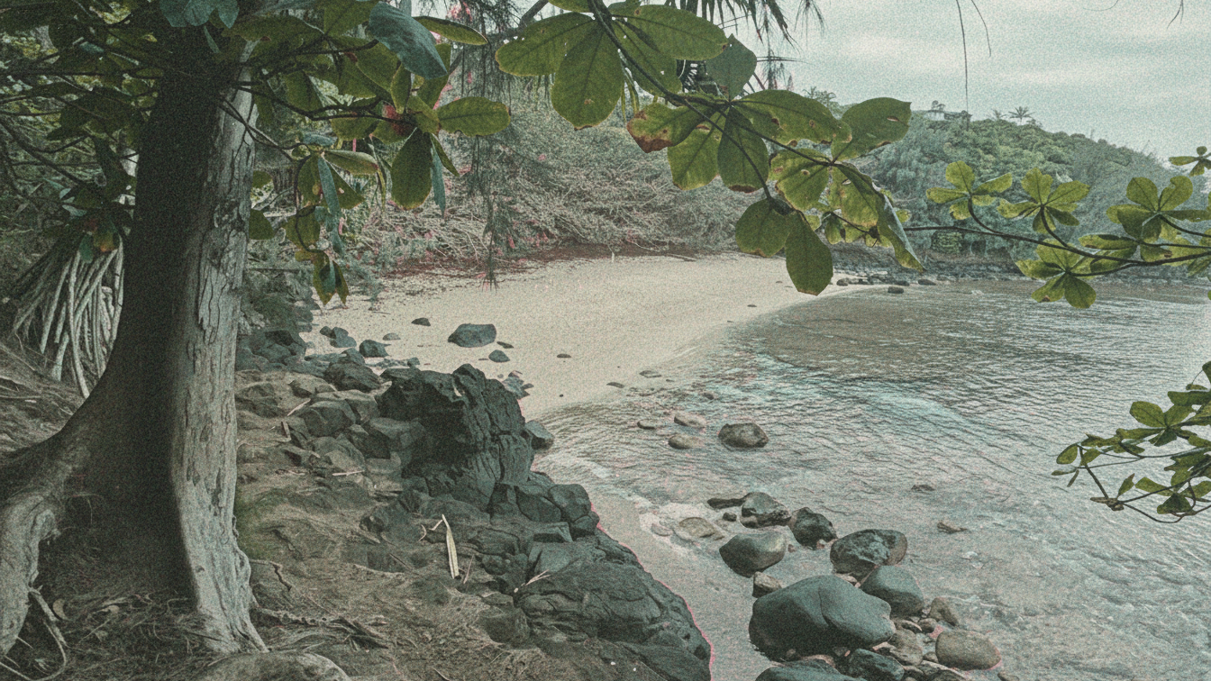
Sealodge Beach delivers what most North Shore Kauaʻi beaches don't: consistent solitude. The mechanism is access — an unmarked, unmaintained descent off Kamehameha Road in Princeville that runs 10–15 minutes and gets steep enough to deter casual foot traffic. At the bottom: coral-and-lava-rock sand, cliff faces, and an open Pacific horizon. No facilities. No lifeguards. Low crowd count by design.
The Trail
The trailhead sits at the end of Kamehameha Road in Princeville (zip 96722). The path carries no signage and no official maintenance. Expect uneven terrain, root exposure, and sections that turn significantly slippery after rain — which on the North Shore happens frequently. Trail time is approximately 10–15 minutes one-way. Closed-toe footwear is the minimum; trail runners outperform sandals on the descent.
The route passes through dense coastal vegetation before the ocean becomes audible. The final approach opens onto a cliff-framed cove — coral-and-lava-rock sand, large rock formations along the shoreline, and a reef line visible offshore.
At the Beach
Ocean conditions: Swimming is not recommended due to strong currents. Snorkeling is viable in calm conditions. No lifeguards on site — assess conditions independently before entering the water.
Sand composition: Coral and lava rock, not fine white sand. Coarser texture and darker color than Poʻipū's resort beaches. The lava rock formations along the shoreline are a distinct photographic feature, particularly in late-afternoon light.
Wildlife: Sea turtles and Hawaiian monk seals use this beach. Monk seals are federally protected under the Marine Mammal Protection Act — maintain at least 50 feet of distance if one is resting onshore. Do not approach, feed, or disturb.
What to Pack
No on-site facilities means self-sufficient from the trailhead:
- Trail runners or closed-toe shoes — not sandals
- Water and food for the full outing
- Sunscreen and sun cover
- Waterproof bag for camera gear
- Trash bags — pack out everything you pack in
Optimal timing: early morning or late afternoon for cooler temperatures and better light for photography. Check weather before the hike. North Shore conditions shift fast, and a wet trail above lava rock is a different proposition than a dry one.
Staying Near the Beach
The Sealodge condo complex sits directly above the trailhead. Many units are vacation-rentable through Airbnb, VRBO, or private management companies — direct beach access is a functional amenity for guests, not just a marketing line. For investors evaluating Sealodge as a rental property, run the STR Report on active Sealodge units for current revenue data by unit type. Ask Moku to stack Sealodge against Pali Ke Kua or Hanalei Bay Resort on rental yield and owner flexibility.
Beyond the Beach
Princeville's range from the Sealodge trailhead:
- Hanalei town — 10 minutes west. Dining, local retail, and the bay overlook on the way in.
- Princeville golf — Prince Course and Makai Course on resort grounds.
- Kīlauea Lighthouse — 10 minutes east. Seabird colony, National Wildlife Refuge, unobstructed ocean views.
- Kapaʻa — approximately 30 minutes south on Kuhio Highway. Larger grocery and dining options for longer stays.
About Moku Intel
Moku Intel is a Kauai real estate intelligence platform — live MLS, vacation-rental revenue data, cost-segregation and 1031 modeling, and an AI research assistant. Built in partnership with Henry Beam, Real Estate Salesperson, Hawaiʻi, who handles showings, comp pulls, and transaction work when you're ready.
Keep reading

Thinking about Kauaʻi?
Six months out or ready this quarter — fifteen minutes with a licensed Kauaʻi specialist usually answers whether the island is the right call for your situation.